Friday, September 24, 2010

Ascension Island 7 Wideawake terns

Photos uploaded Sept 24th but blog posted Oct 9th

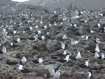
Most of the sea birds on Ascension Island nest on Boatswain Bird Island where there are no rats or feral cats to predate them. However there are about 400,000 wideawake or sooty terns nest on a lava flow known as the Wideawake Fairs close to the air base. We went to see them on both our visits to the island and they are an amazing sight. As there is such a plentiful supply of flying fish (one of their main food sources) all year round the terns here breed every 9-10 months so the first time we saw them they had eggs and this year although we were a little earlier they had chicks.


As you approach the fairs there are thousands of birds flying around you and swooping down over your head. They are incredibly graceful and beautiful.


They lay a single egg just in a small scrape on the ground or even on a rock.

The chicks are dark and mottled and incredibly camouflaged against the lava, so that it is hard to spot them.


There are at least 6 chicks in this photo!


Ascension Island 6 Devil's riding school


Photos uploaded September 24th but blog posted October 7th

Another letterbox walk we did was to the Devil's Riding School. It was only a short walk from the road to the edge of this old volcanic crater. We walked over these amazing rocks which were very brittle and sounded like porcelain.

There were some very unusual formations around the crater rim.


Inside the crater it looks almost like a circular track around the edge like a race track - hence the name.


The letterbox was on a high spot on the far edge of the rim and easier to find than some of them.

From there we had a good view to the south of the island and the wind turbines.

There were quite a lot of prickly pear plants growing inside the crater as well as Mexican thorn bushes which are becoming prolific over much of the island.


Ascension Island 5


Pictures uploaded September 24th but blog posted October 3rd.

By the time we had climbed back up from Spire Beach the sun was shining again.

This photo was taken from near where we had parked and looking down into Cricket Valley, an old volcanic crater. On the skyline you can see the NASA station, which was operational from 1966 until the early 1990s. The building is now used for scout camps.

Looking the other way we had a good view of White Horse mountain which we climbed this year.
As we really are gluttons for punishment we decided to try one more walk before the day was done so headed on up Weatherpost which was quite a scramble. Our main problem was finding the letterbox when we got up to the plateau as the instructions were rather vague and there were a lot of trees. As the clouds descended again and dusk was approaching I was inclined to give up but then we found it. It felt quite an achievement having come about 2,000 feet almost straight up from Spire Beach.

However I realised that our achievement paled into insignificance when I thought about these land crabs. These large crabs live in burrows on the mountains, even as high as the top of Green Mountain, and range in colour from yellow and orange to reddish purple. When the female lays her eggs she carries them as a spongy mass under her abdomen all the way down to the sea to release the larvae into sea water.

On both our visits to Ascension Island we were very puzzled by these small piles of tiny white (but occasionally coloured) papery things, looking almost like soft sea urchin spines, which we found in lots of the places we visited. The mystery was eventually solved when we questioned a lady at the museum. They are small shreds of paper put out by the local Hash to mark their trails!

This must be one of the world's more unusual golf courses. The One Boat golf club.

This plant is Euphorbia origanoides. It is unique to Ascension Island and an endangered species. We only saw it in one location. There are also several endemic ferns which grow on Green Mountain.

Ascension Island 4 Spire Beach

Pictures uploaded September 24th but blog posted October 3rd


Having done the gentle walk to the dew pond on Green Mountain we decided to try one of the more challenging letterbox walks to Spire Beach. I did wonder what I was letting myself in for when I read this warning sign at the beginning of the descent!

Wev had driven out to the eastern end of the island past the old NASA station and along a track before starting walking. You start at about 1,500 feet above sea level and descend down a rocky gulley.

I must have managed to get ahead of Simon to take this photo.

There were lots of wild guavas growing in this gulley which provided some welcome refreshments.

About half way down to the coast this gulley dropped off in a precipice and we had to cross over into another gulley which was a bit precarious but there are a couple of chains attached to the rocks to give you something to hold onto.

From here it was much more barren, with hardly any vegetation, and some interesting volcanic rock formations.

As we descended so did the clouds and by the time we reached the beach it had started to rain but it didn't last too long.


This letterbox wasn't hard to find in a pile of stones in the middle of the beach and people had assembled an odd collection of flotsam and jetsam around it. It is always interesting to read the visitors books. I think it was about a month since the previous visitors to us had been there so if you had an accident you couldn't count on someone coming along very soon!


The rain cleared while we ate our picnic lunch and watched the many sea birds flying around us and around Boatswain Bird Island just off the coast. This small island is the nesting site for thousands of birds including tropicbirds, frigatebirds, boobies and noddies.

There were also some on the cliffs above us. Having enjoyed the rest we then had to climb back up the way we had come down!


Ascension 3 Green Mountain


Green Mountain is the oldest and highest part of Ascension Island, rising to 859 metres. A steep, winding road, called the Mountain Ramps, with some very sharp hairpin bends goes as far as the Garden cottage, which you can rent, and the Red Lion, which used to house farm workers. The top of the mountain is often in the clouds and it is much damper up there.


A garrison of about 60 Royal Navy men was established on Ascension Island in 1815 and they collected water from a ravine on Green Mountain known as Dampiers Drip. They made a path up the mountain, built the stone garden cottage and established gardens to supply fresh food.

In 1821 they were replaced by Royal Marines who cut a network of paths around the mountain, extended the gardens into a farm, built barrack blocks and water catchment areas like this one.


In 1831 Captain Brandreth found water at a depth of 30 feet in Breakneck Valley. A tunnel was made through the mountain to carry pipes through which water was pumped to the main tanks near the Red Lion. We had taken torches with us and walked right through the tunnel although the exit was partially blocked by an earth fall. When we visited this year a firmly padlocked gate had been fitted over the entrance!


There are some fantstic views out over the island.


Lots of different plants were introduced by the marines and also sent from Kew gardens and there is a wide variety of lush vegetation and flowers.

From the end of the road you can follow a path up to the summit peak through dense areas of ginger plants.

You then enter a bamboo forest which has spread from plants introduced in 1877. It is extremely damp and slippery but there is a board walk through the bamboo.

Near the summit is the Dew Pond, constructed in 1875. There are waterlillies and some tiny goldfish in the pond.

You might be surprised to find an old letterbox next to the pond. There is a series of walks around the island which you can buy a guide to and at the end of each walk is a letterbox of some sort containing a visitors book and a rubber stamp and ink pad so you can stamp your guide to prove that you have been there. During our 2 visits we have done a lot of the walks (more details in future blogs!)

The summit of the peak is marked by an old piece of anchor chain . Legend has it that sailors used to swing the chain above their heads to try to make it rain but I think it is unlikely.


Ascension Island 2


Photos uploaded on September 24th but blog posted 29th


Large numbers of green turtles come to Ascension Island to breed, many on the beaches just by Georgetown, but unfortunately we have never visited at the right time of year to see them. These pools were built 1829 and were used for holding live turtles before they were loaded onto ships to provide fresh meat for the sailors (and turtle soup for the Lord Mayor of London and the Lords of the Admiralty.


There are quite a number of "wild" donkeys and sheep wandering around, both in town and out in the countryside. In fact they are very tame and seem to get well fed!

The island is volcanic and many of the hills are still bare cones of volcanic ash. This is Sisters Peak and an old lava flow can be seen in the foreground.

Much of the coast is very rugged, especially where lava flows have entered the sea.

This is English Bay a few miles from Georgetown. This is where we went to do some fantastic snorkelling. Providing the sea isn't too rough it is usually fairly safe to swim here. We saw a large number of different fishes, some very colourful, and some large morray eels of 2 different kinds. Last year we saw a young green turtle in the sea here which had lost one flipper but seemed able to swim well without going round in circles. This year a hawksbill turtle swam up and took a close look at us which was very exciting. Near English Bay is the BBC South Atlantic relay station and also the islands power station and desalination plant.


This is Comfortless Cove, another popular spot for swimming, although it is very small. From around 1830 this small inlet was used to land sailors who had contracted yellow fever. They were quarantined in this area and many did not survive.


Just inland from the cove is Bonetta cemetary where some of the victims were buried, although I can't imagine how they dug graves in this inhospitable landscape.

Comfortless Cove is also where the first submarine telegraph cable was brought ashore in 1899 and Ascension Island soon became the centre of a web of cables stretching between Europe, Africa and America.